
The Blue Ridge Parkway: America's Favorite Drive. October 12-14, 2015
I was cursing my luck. It was foggy. Hopelessly foggy. It was my first time traveling the famed Blue Ridge Parkway, and a silvery cloak of fog had thrown itself over the mountains, putting a damper on my semi-spontaneous decision to get away for a few days and peep at some leaves. I could barely see in front of my car, let alone the vistas I knew were just beyond my thoroughly limited line of sight.
Frustrated, I drove on. I had entered around Asheville, NC and was traveling south along the parkway. The forecast had seemed favorable: 65-70 degrees and full sun during the day, 35-40 degrees and clear at night. The foliage was predicted to be at penultimate beauty. I was there the week before the color peaks. By the end of the month, the trees would begin to fade, rapidly and communally shedding their charms.
Turn after turn of low visibility and few cars, I began to question if it was worth it to camp and hike in the shrouded fog. Perhaps I could come back another time.
It happened the way epiphanies do. The light peaks in, slowly warming the mind to an idea, then flashes in an instantaneous blaze of understanding. I climbed a steep ridge, carefully curving the car well below the 45 mph speed limit.
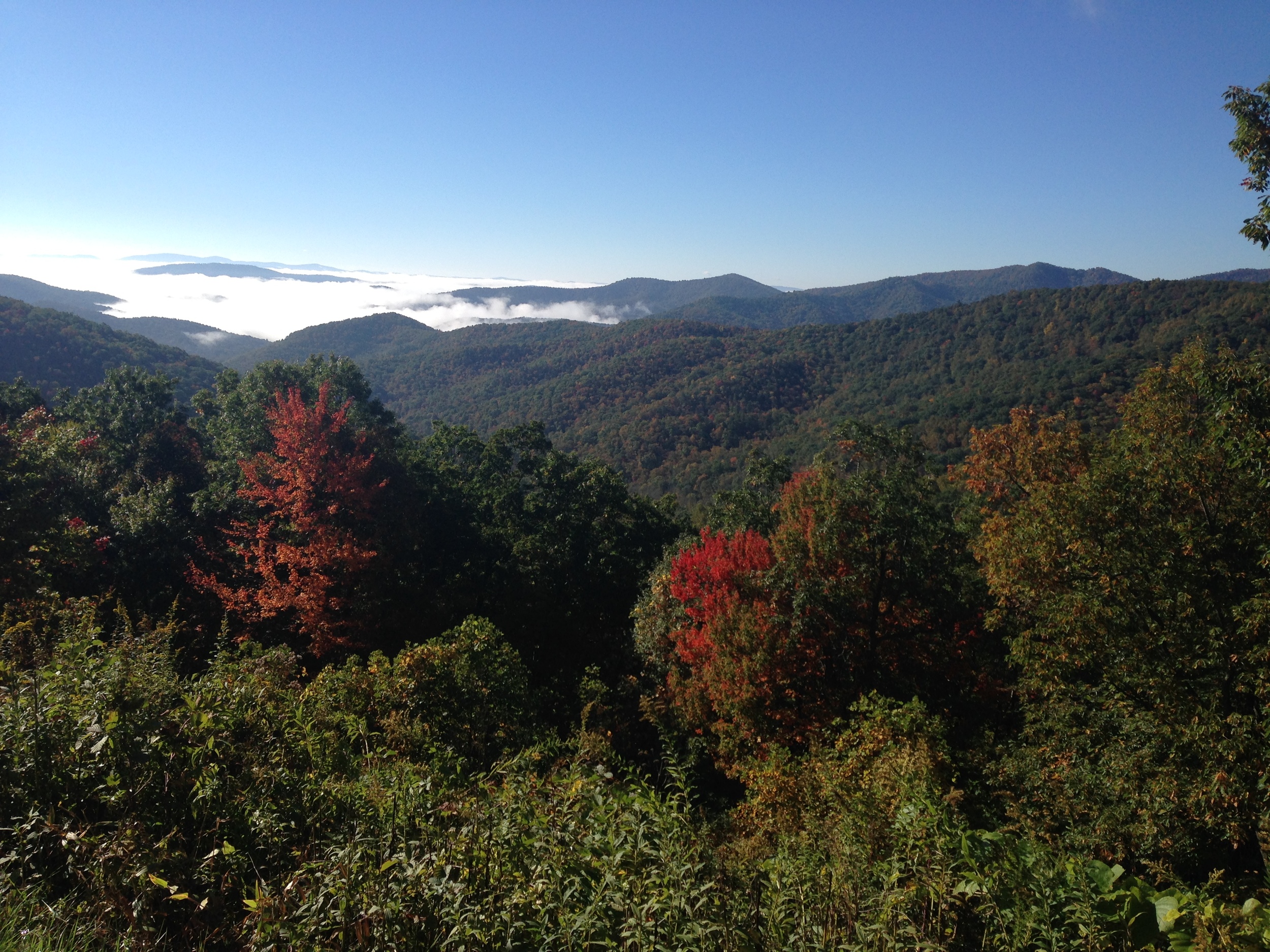
Shapes began to form from the amorphous gray blanket of fog. Trees, mountains, rocks. I became aware of an opening slope to my left. Hues of garnet and gold emerged, balanced by long ribbons of distant blue.
Cresting one last hill, I suddenly broke through the cloud cover, and all doubt and disappointment vanished.

Those ribbons of blue crystalized into a series of mountain ranges. Packed tightly together, they were simultaneously far off and up close. The fall color I had been promised blazed from every tree. I had arrived.

The Blue Ridge Parkway is called "America's Favorite Drive." For nearly 500 miles, it winds slowly and deliberately, snaking a trail from Virginia to North Carolina, burrowing deep into the heart of Appalachian country. It passes through or around forgotten small towns, historic sites, numerous forests, watersheds, lakes, and of course, sweeping valleys and undulating mountain peaks. The Parkway lays claim to some of the most majestic views in the eastern United States and provides access to countless trails that deliver its visitors to remote places of unspoiled beauty.
The Parkway is not a national park but is maintained by the National Park System (NPS.) It is America's most traveled stretch of the NPS, the nation's longest linear park unit, and the longest national road that was planned as one unit.
It is 469 miles long, connecting Virginia's Shenandoah National Park to the Great Smoky Mountains National Park (which is shared by North Carolina and Tennessee.) The Parkway travels through four National Forests: George Washington and Jefferson forests in Virginia, and Pisgah and Nantahala in North Carolina.
It is also a National Scenic Byway and an All-American Road. A National Scenic Byway is a road recognized for one or more of six "intrinsic qualities" by the US Department of Transportation . The qualities are: archeological, cultural, historic, natural, recreational, and scenic. An All-American Road is one that meets two or more qualities.

For larger image click
Begun in 1935 under President Franklin D. Roosevelt, the parkway was officially authorized under the NPS by Congress in 1936. It took 52 years to complete. According to the NPS website, by World War II, about one-half of the road was completed and by the 1960s, all but one section was opened to the public. The last stretch, the Linn Cove Viaduct at mile marker 304, was laid in 1987.
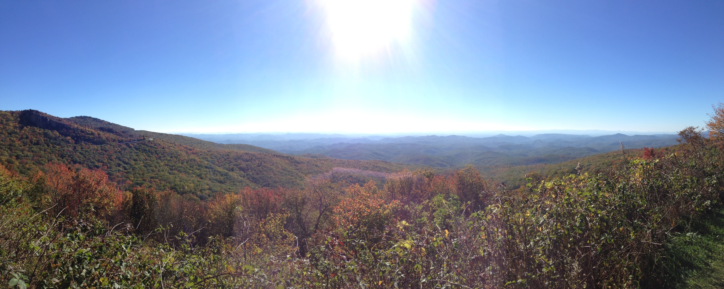
The name "Blue Ridge" corresponds to the Blue Ridge Mountains, which are part of the entire eastern Appalachian Mountain system. The Blue Ridge Mountains run from north Georgia into Pennsylvania. On the Parkway, the Blue Ridges run from Milepost 0 at Rockfish Gap, VA to Milepost 355 near Mount Mitchell State Park, NC. Typical elevation is 3,000 feet.
At Mount Mitchell, the Parkway curves west through the Black Mountains and the Craggies before descending toward Asheville. From there, the road climbs to elevations over 6,000 feet in the Balsam Mountains, before arriving at its southern terminus: the Great Smoky Mountains.

Approximate route of Blue Ridge Parkway, 469 miles through Virginia and North Carolina.
My two night, three day journey would take me from mile marker 418 to 295, all in North Carolina. With some backtracking, the trip encompassed approximately 150 of Parkway's 469 miles.
Day 1 : Monday October 12, 2015: Graveyard Fields and Craggy Gardens
I began my Parkway journey by traveling south before turning around and heading north. I arrived at Graveyard Fields around 10:30 am, intent on hiking to its two waterfalls, Upper and Lower Falls.
The overlook information sign reads:

Quite the description.
Today, the relatively flat fields are in a state of regrowth. They have a scrubbed, patchy appearance in parts, where spindly grasses struggle to survive. In other places, the river that connects Upper and Lower Falls meanders peacefully through wetlands.

Lower Falls.
Accordingly, the 3.2 mile loop hike is wet, muddy, and - considering the high elevation- quite easy. I first trekked downhill to Lower Falls. A quick 15 minute descent took me to the base.

Upper Falls.
Turning around back the way I came, I began the hike to Upper Falls, which took about one hour. Many people were out on the trail. The flat terrain made it possible for young and old to make the walk. I saw many elderly couples, some with canes, making the journey. A young woman on crutches was bravely hopping along.
Temperatures were in the 70s. Having lived in Vermont for six years, it was a treat to hike in mid-October in such warm weather.
The Upper Falls were more dramatic than the Lower. I munched on a pear and sat on a rock under the falls. I didn't stay long, and soon began the walk back down the trail.
Back at the parking lot an hour later, I was soon on the parkway heading north. I stopped at the Folk Art Center at milepost 382 and browsed local pottery and crafts. I wanted a memento from the trip, so I bought some postcards, a long sleeve Blue Ridge Parkway tee, and a parkway baseball hat with a black bear on the front.
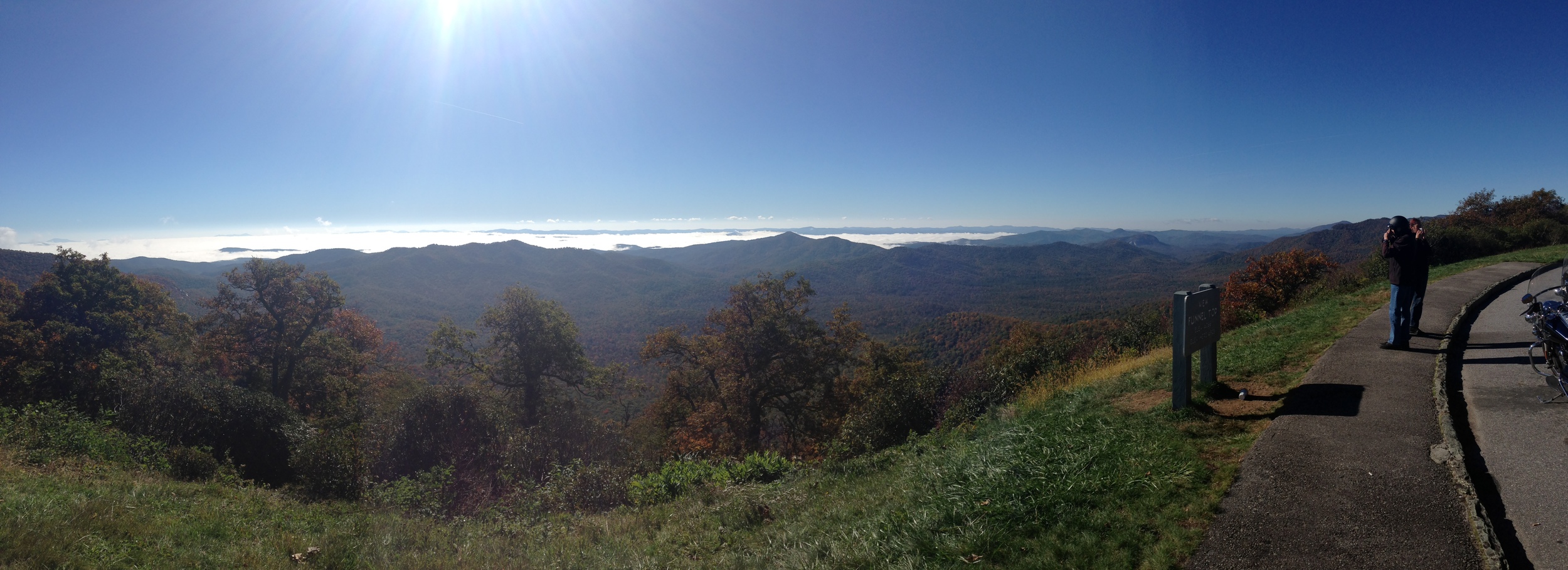
I continued north toward Craggy Gardens, at milepost 364. It was about four by the time I arrived, and I was uneasy because I still had another hour to drive to my camp for the night, at Curtis Creek. The sun sets much quicker in the mountains. Knowing I would probably be pulling into camp at six meant I'd be setting up in near dark.
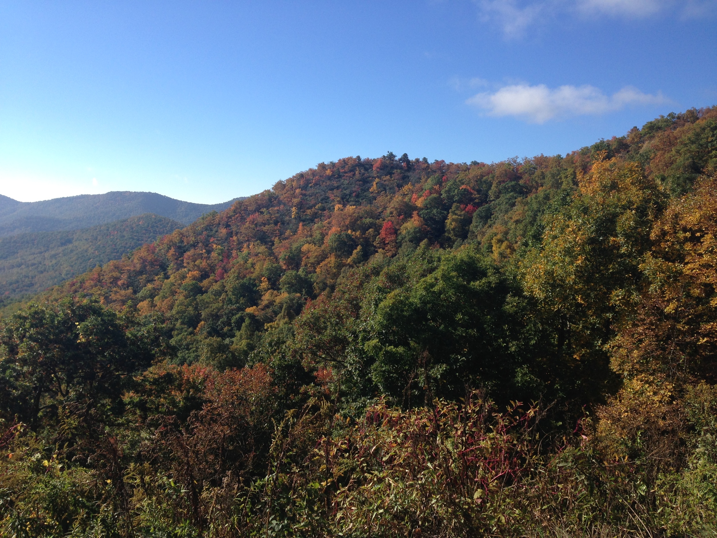
Craggy Gardens is an overlook with a 360 degree view of the surrounding mountains, ideal for picnicking and admiring the rhododendrons in the spring. The Craggy Mountain range is also part of the Blue Ridge system.
The hike was billed as a short and steep half hour climb, which was fairly accurate. Unfortunately, in October the blooms are all gone, and the area was mostly dead with few autumn leaves. I can imagine that in spring it would have been breathtaking, but it seems I caught it at the wrong season. I quickly turned back, anxious to get to camp.
I intended to camp at Curtis Creek, about six miles off the parkway. The parkway has designated campgrounds along the way for easy access, and these campgrounds are highly developed. Trailside and backcountry camping are not allowed on the parkway, but are allowed in some parts of adjoining state or national forests- one has to exit the parkway and enter through other means, however.
Curtis Creek was supposedly more remote, situated along a creek with primitive sites for $5.00 a night. However, when looking online, I was unable to see how far out of the way it really was. I ended up passing the road, for there were no signs. When I finally figured it out, I saw that I had six miles down a dirt road. In my grandfather's slow moving, boat-sized Lexus town car (without four wheel drive,) I wasn't sure if I would be able to navigate the rough road. Additionally, the campground had no website or contact info, I had no reservation, no cell service, and was alone. Not the ideal combination. It was getting dark, but I decided to drive a bit down the road to see if the car would fare alright.
Five minutes in, it was clear this was not going to work. I turned around and decided to try my luck at one of the developed campgrounds. I had passed the Mount Mitchell campground (milepost 355) a half hour ago, so I backtracked there and raced to the ranger headquarters. I managed to catch him as he was leaving, but he told me all the sites were full. He pointed me north to Crabtree Meadows (milepost 340) and said I could try for a site there.
I was feeling more than a little rushed and panicked at this point. I had to remind myself that this was not a bad situation and to just calm down. I drove to Crabtree Meadows and the gate was thankfully still open at 7:00. The campground had self-registration, so I was able to find an open site and deposit cash in the office box.
Relieved, I quickly set up my tent and heated up soup. It was already getting chilly, so I packed it in for the night by 8:30.
It was my first night camping alone. I had camped plenty of times with others, but not solo. And really, I wasn't alone in a true sense, since I was at a campground with plenty of others a few minutes' walk away. But, it was a good test for me.
At 1:00 in the morning, with a rainstorm blowing and sounds of loud crashes and crunching around my tent, I was fully convinced and terrified that a bear had paid me a visit. My food was in the car, so I tried to calm myself. There was nothing in the tent to attract the bear. I wasn't going to be mauled to death.
Still, I was wide awake and stayed up for another hour, analyzing every cracked twig and rattle of the tent. By 2:00, the fierce wind slowed a bit, and I uneasily fell back asleep.
Day 2: Tuesday October 13, 2015- Linville Gorge

At dawn, I woke for the day and investigated around my tent and the car. Some branches and enormous acorns had fallen on and around the car (the source of the crashing.) The crunching could have been small critters, or my overactive imagination. I would never know.
I made a quick breakfast and packed up, hitting the road by 9:00. My destination for the day: Linville Gorge, milepost 316.
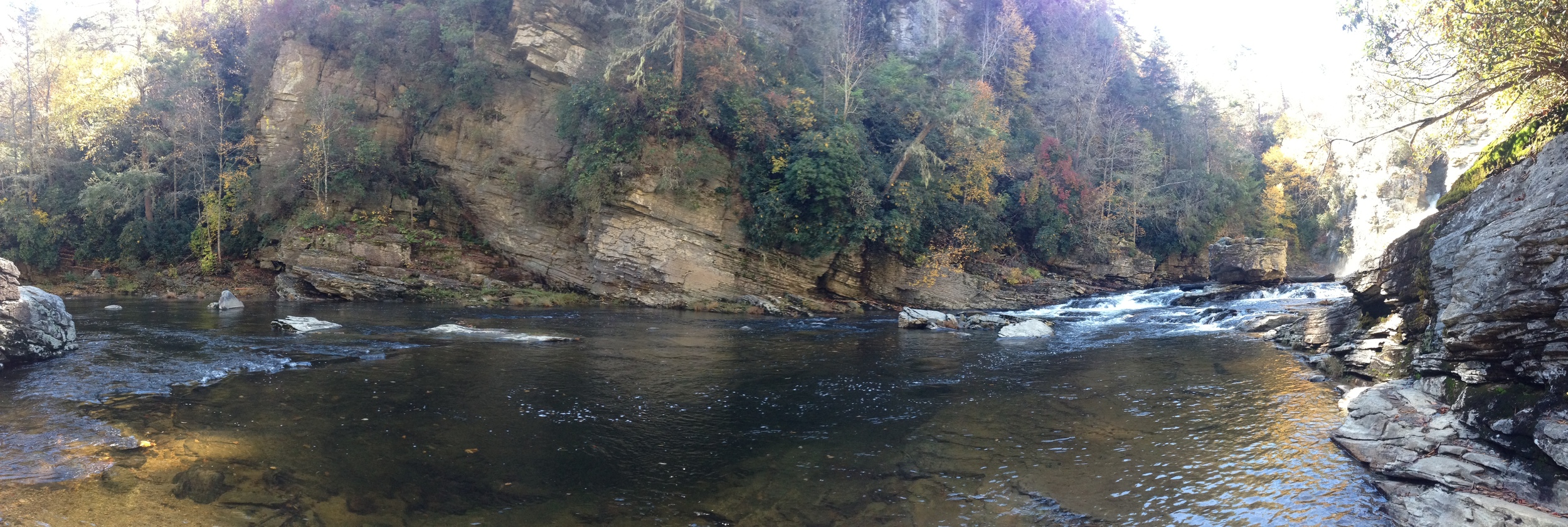
Dubbed "The Grand Canyon of North Carolina," the gorge is also considered by some to be the Grand Canyon of the eastern US. The gorge itself- with walls of nearly 1,400 feet- and the river that traverses it are part of the Linville Gorge Wilderness area of the Pisgah National Forest.

Classic, far-away glance of the falls, from Erwin's View Trail
The wilderness area encompasses nearly 12,000 acres. The highlight is Linville Falls, a towering waterfall accessible by a series of short hiking trails from the visitor center.
From the visitor center, you can go straight and continue to trails revealing top and middle views of the falls, or veer left and head to the floor of the falls.
I ventured forward first, aiming to view the waterfall from top to bottom and start at the highest point.
The first I tackled was Erwin's View, a 1.6 mile round trip trail that delivers four overlooks at the highest elevations.
There were many people on the trail, all clamoring for a look at one of the most popular waterfalls in the state.
Chimney's View is lower on the trail and closer to the visitor center. It shows you a middle view of the falls.
The river that cuts through the gorge has an interesting history. At the Chimney View, a series of information panels provided by the NPS illustrate "Death on the Long Hunt."
The Cherokee had lived in the area for centuries and used the river as a seasonal hunting ground and to transport goods. The named the river Ees-ee-ogh, meaning “River of Cliffs.”
Once European settlers began to encroach on Native American territory, tensions ensued. Small fights erupted as more white hunters and trappers infiltrated the land and the Cherokee retaliate.
In the summer of 1766, William Linville, his son, John, and a 16 year old boy named John Williams- plus a local guide- were camped at the river. In these days it was common for men to go on hunts lasting many months. The party was ambushed by local Native Americans. Linville and his son were killed, and 16 year old Williams was shot, but escaped with the guide.
The Native Americans, of course, were eventually completely removed from their land. The river now has the official name of Linville.
Grim history aside, the most spectacular viewpoint for me was at the Plunge Basin trail, at the floor of the waterfall. After a cramped, steep descent through tangled vines, roots, and tree trunks, you emerge at a sandy beach by the rushing river.

Plunge Basin, the floor of the falls.
There is a large rock for standing and admiring the falls, and the sandy beach is perfect for a snack and a rest. I stayed for about half an hour, listening to the thunder of water crashing.
By the time I reched the visitor center, it was still early in the afternoon. I camped nearby at the Linville Falls campground and set up with a few hours of daylight left to sips some beers and relax. Bedtime came early again, with the sun gone by 8:00.
Day 3: Julian Price Lake and Blowing Rock, NC

My last day on the parkway dawned clear and cold. It was between 32 and 35 degrees, and I could feel the snap of mountain air in my lungs.
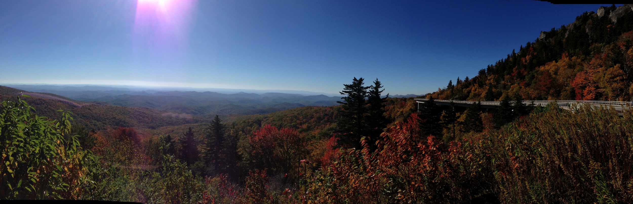
My first stop was the famed Linn Cove Viaduct. The viaduct was the last chunk of the parkway to be completed, in 1987. It is a 1,243 foot long concrete segment that winds around Grandfather Mountain. It is considered an engineering marvel, and one that is kind to the environment, because it was constructed without disturbing or removing parts of the existing rock and mountainside.
From the NPS website:
"Engineers were faced with a serious question: How to build a road at an elevation of 4,100 feet without damaging one of the world's oldest mountains? National Park Service landscape architects and Federal Highway Administration engineers agreed the road should be elevated, or bridged, where possible to eliminate massive cuts and fills. Figg and Muller Engineers, Inc. developed the bridge design and construction method. The result: the Linn Cove Viaduct at milepost 304.6, the most complicated concrete bridge ever built, snaking around boulder-strewn Linn Cove in a sweeping 'S' curve."

Classic wraparound view of the Viaduct.
A typical design would have cut out part of the mountain and filled in a road. Instead, segments of the "bridge" were precast and then lowered into place. The NPS site describes the process:
"The Viaduct was constructed from the top down to minimize disturbance to the natural environment. This method eliminated the need for a "pioneer road" and heavy equipment on the ground. The only construction that occurred at ground level was the drilling of foundations for the seven permanent piers on which the Viaduct rests. Exposed rock was covered to prevent staining from concrete, epoxy, or grout. The only trees cut were those directly beneath the superstructure."
It truly is impressive, and the view is one of the most famous on the parkway.

Watery reflections at Price Lake.
My last stop was at Julian Price Memorial Park, milepost 297. It sits at the base of Grandfather Mountain, near the town of Blowing Rock, NC.
I did a short hike around Price Lake, about 2.7 miles roundtrip. I spied some excellent lakeside campsites at the campground and found myself wishing I had stayed the night there. Another time.
My time at the Parkway was over. I left Price Lake and headed into Blowing Rock for lunch and a local brew. I filled a growler of some North Carolina amber ale, and began the two hour journey home. It was sort of surreal how close the Parkway was to home, but how different, geographically and visually, it was. I felt like I had gone on a long quest, but I was really only in South Carolina's neighboring yard, so to speak.
The Parkway is a stunning slice of some of the most majestic views of the Eastern mountain ranges. To experience it fully would require more than two and a half days. I never even entered the Virginia half, and skipped much of the North Carolina landmarks. There are big name mountains (Mitchell, Pisgah, Grandfather) to hike, deep forests to enter, and numerous swim holes and streams to splash in.
Take the opportunity to embark on a slow drive up or down this national treasure. Wind your way. Stop at kitschy general stores. Camp. Swim. Hike. Look. And watch for bears...

Foliage dotting the horizon near the Linn Cove Viaduct.