"Winter" in the Carolinas
Moving from Vermont to South Carolina has come with many adjustments, but perhaps none as drastic as the weather. This time of year in Burlington, I would be trudging through the ever-present crust of ice and snow, bracing whipping winds and freezing temperatures. Spring would still be several months away (if it ever sprung at all.) Daylight would be scarce.
Not so in the Palmetto State. Granted, we had an inch or two of snow a few weeks ago and the city went into panic. Stores and restaurants were closed and the roads were impassable, with no salt or sand. I stayed home for 48 hours straight.
But on the whole, the "winter" here is incredibly mild, particularly in this El Nino year. A few days before Christmas, it was in the 70s. Now, in February, it's averaging 40-50 in the day, but sometimes it breaks into mid 50s and low 60s. Nights can be chilly in the 30s, but it still feels warmer than the cold snap of that Lake Champlain wind up in Burlington. Plus, daylight is almost an hour longer.
This balmy climate means I can get outside a lot more often than I would living up north (since I'm not a skier, my Vermont winters were nearly 100% indoors.)
Here are some snapshots from some of my recent hikes and drives in South (and North) Carolina.
Crowders Mountain State Park, North Carolina // January 14, 2016
Crowders Mountain is just over the state line and actually connects to Kings Mountain State Park and National Military Park in South Carolina, which I visited this November.
Inside the park office, visitors can read about the history of Crowders. In the early 1970s a mining company began exploring and collecting samples form the mountain, seeking to purchase the mineral rights. Grassroots efforts by local citizens and organizations persuaded the state government to protect the area and set it aside as a state park.
In 1973 the state officially designated the area as Crowders Mountain State Park and it opened to the public in 1974. The Pinnacle, the second peak, was added to the park in 1987. In 2000, the Crowders was officially expanded to connect with the Kings Mountain parks in South Carolina.
Crowders is generally less visited than the Kings Mountain parks, because it has more difficult trails. But after completing the summit hike to Crowders peak, it has become one of my favorite parks in the area.
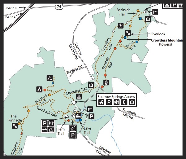

I decided to do the Crowders trail, to the Rocktop trail, then the Tower trail to finally access the summit, and take the Backside trail on the way down to reconnect with Crowders. All together it would be about 6 miles roundtrip.
Setting off from the Sparrow Springs visitor center, you walk the same trail to access Pinnacle and Crowders. Choosing Crowders to the right gets you on your way.
The first mile and a half of the Crowders trail is easy forest walking, over nice bridges and streams. Once you cross the park access road, you quickly come to the dividing point between continuing on Crowders proper and taking the steep, entirely rock-face trail- Rocktop.
I chose that one because the visitor center park guide advised me it's easier to rock scramble on the way up than the way back down, when you're tired and could make a false step. Apparently, this is no joke. Signs like this greet you when you reach the trail:

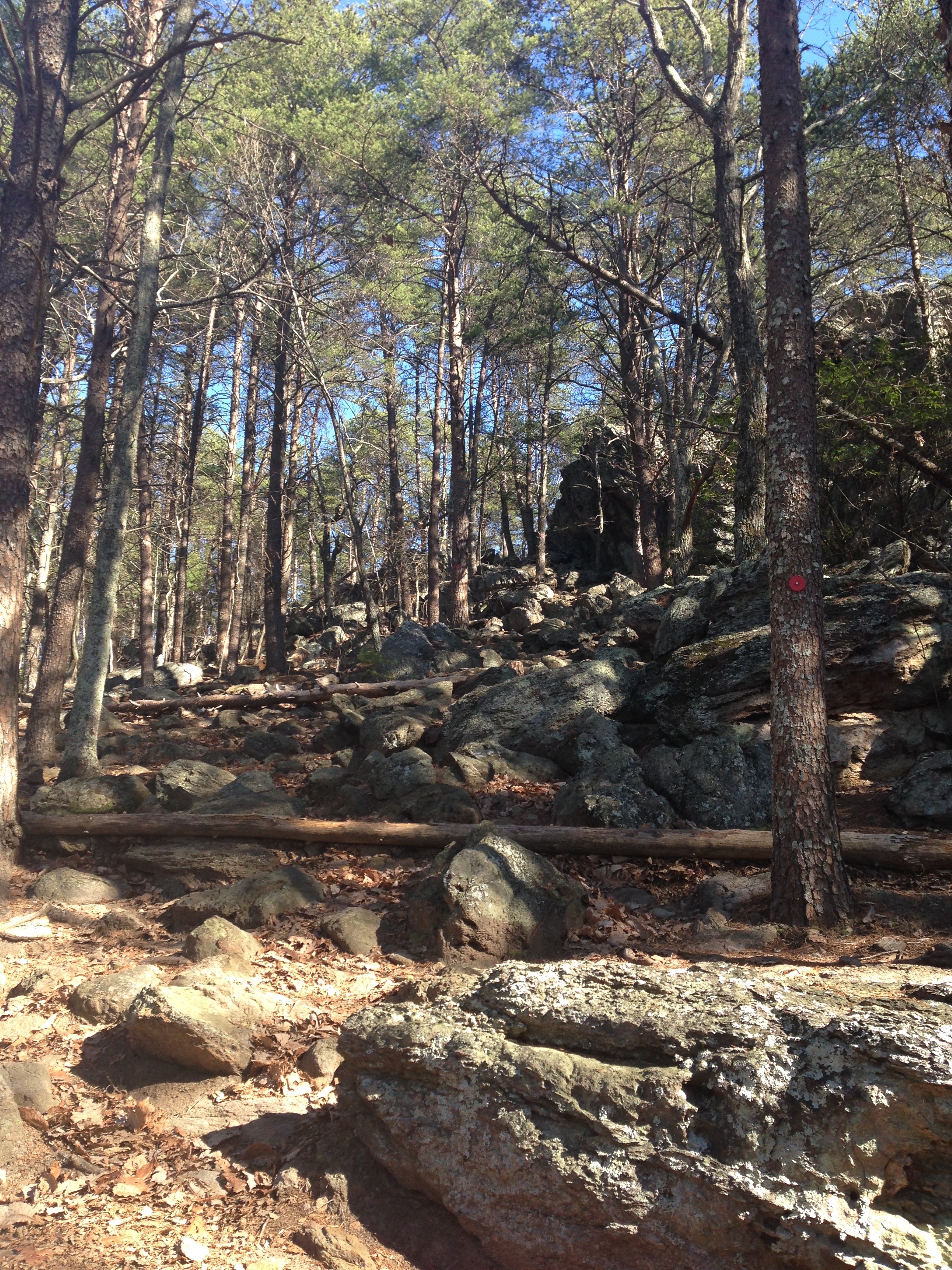
Comforting, no? The trail is red blaze, and you basically just have to hop, crawl, shimmy, and inch your way up and over various rock faces, keeping an eye on the blaze to make sure you're going in the general direction.
It was about 40 degrees when I started on the Rocktop trail. Within minutes I had shed my fleece and unzipped my jacket, wearing just a tee shirt underneath. There were a few people hiking before me and after me, and the struggle was universal.
This hike actually reminded me a lot of Vermont hikes like Camel's Hump and Mount Mansfield. Craggy rocks, scrambling, lots of careful hand and foot work. And lung work. Because you will be gulping air.
It's 1.4 miles on this trail, and although it was strenuous, I was glad I did it on the way up like the guide had suggested. While taking a little rest, I met a couple in their 60s, Mike and Sheila, who were doing a test hike to see if their WEDDING PARTY could make it up the mountain to a flat part of the Rocktop trail. Incredulous, I asked them why.
Apparently, this was where they had their first date, and where Mike proposed. So, they figured "why not get married on the mountain!" I was impressed and a little intimidated.
They reasoned that many elderly members of the wedding couldn't make it, so they got a park employee to volunteer to drive some of the wedding party up an access road so they wouldn't have to do much hiking and could just hop out and walk a short ways. This is where the Tower Trail comes in. I met Mike and Sheila basically at the end of Rocktop, a short distance from the access road, which leads to the Towers on top of the mountain.

We talked and hiked our way along the Tower Trail and around the towers to continue to the summit overlook.
Mike and Sheila had only been dating for six months (!) and he had proposed after the first two months. They said, at their age, "you just know."
Their adult children, and young grandkids, would be coming to the wedding, along with their friends who "all think we're crazy," they laughed.
It was great talking to such an active and, yes a little crazy, couple. They are definitely living life their way. It was certainly inspiring!

We made it to the summit and Mike and Sheila quickly scrambled off to explore more plans and trails for the wedding. I said goodbye, unpacked my lunch, and took in the view. You don't get a traditional sweeping summit view. It's more like pockets of overlooks, like the one above.


Cheesin'.
It was a clear day. You could see all the way to Charlotte, NC. And it had warmed up, in the mid 50s. Simply gorgeous.
I stayed for a bit, walking around and admiring the various overlooks. By now it was about noon and many people had reached the top.
After enjoying a leisurely lunch and liters (literally) of water, I was ready to head back down. I still had about 3 miles to go back to the visitor center!

Yikes.
And once again, I owe that park guide a thank you. The way down on the Backside trail begins with a series of 300 steps. I can't imagine going UP those on your final ascent to the summit, so I was grateful to be going down them instead!
The Backside quickly joins up with Crowders to loop back. It was a pleasant, easy woods walk. I ended back at the visitor center around 1:30, where I tried to ignore the large number of taxidermied animals.

Double yikes.
But all in all, it was a gorgeous and challenging hike. I will definitely be back to do the Pinnacle Trail, and maybe one day the 16 miler connector between Crowders Mountain and Kings Mountain.
Paris Mountain State Park, Greenville, South Carolina // January 18, 2016
I started off this day intending to hike the Raven's Rock Loop Trail at Caesar's Head State Park. But, I hadn't realized how high up the trail began. It was an 11 mile drive up a mountain pass, and when I got there, it was 25 degrees and icy. I wasn't too confident my car (grandpa's, with no four wheel drive and used tires) could make it back down the pass without having some ice-related fiasco. Plus it was truly cold and I wasn't dressed for those temps.
So I decided to head over to Paris Mountain near Greenville instead. I had to be there later in the evening to pick up my dad from the airport anyway, so it seemed right.
Lo and behold, the only way to remain in South Carolina and go to Paris Mountain is...to go back down Caesar's Head. So I just kept driving the opposite way over the state line. I stopped in Cedar Mountain at a little diner-cafe for some coffee and a map (no cell service means no GPS. Adventure!)
The woman at the register looked at me like I was a little nuts when I asked the best way to get back to South Carolina without going back over the mountain on Highway 276 South, which is the most direct route (and really the only one). She said, "well, you can keep going North on 276, and you'll reach Brevard, and you can hook up with a smaller highway, 64, there. It's backroads so as long as you don't mind a scenic drive."
Sold. I careened down 276, snaking my way toward Brevard, a mountain college town. On the way, I laughed as I stumbled across this:

Who knew? The things you find when lost, backroads, with no GPS.
I did indeed encounter Brevard about 10 miles later, connected with Highway 64 West, and headed back to South Carolina. I had to connect to 178 East, then 288 East.

Welcome to Bob's.
The woman was right about back roads. I was traveling through the country. And it was lovely. Valleys with morning mist still burning off. Streams off the side of the road. Advertisements for cabin rentals. Truckers at four way intersections, coffees in hand, arms resting on car windows. Tiny towns. And, possibly the greatest roadside bar I've ever seen.
Bob's Place, Sunset SC. Apparently, Bob's is known far and wide as a biker bar, local watering hole... and the site of one of the South's more gruesomely fascinating phenomenons: "you kill it, we grill it."
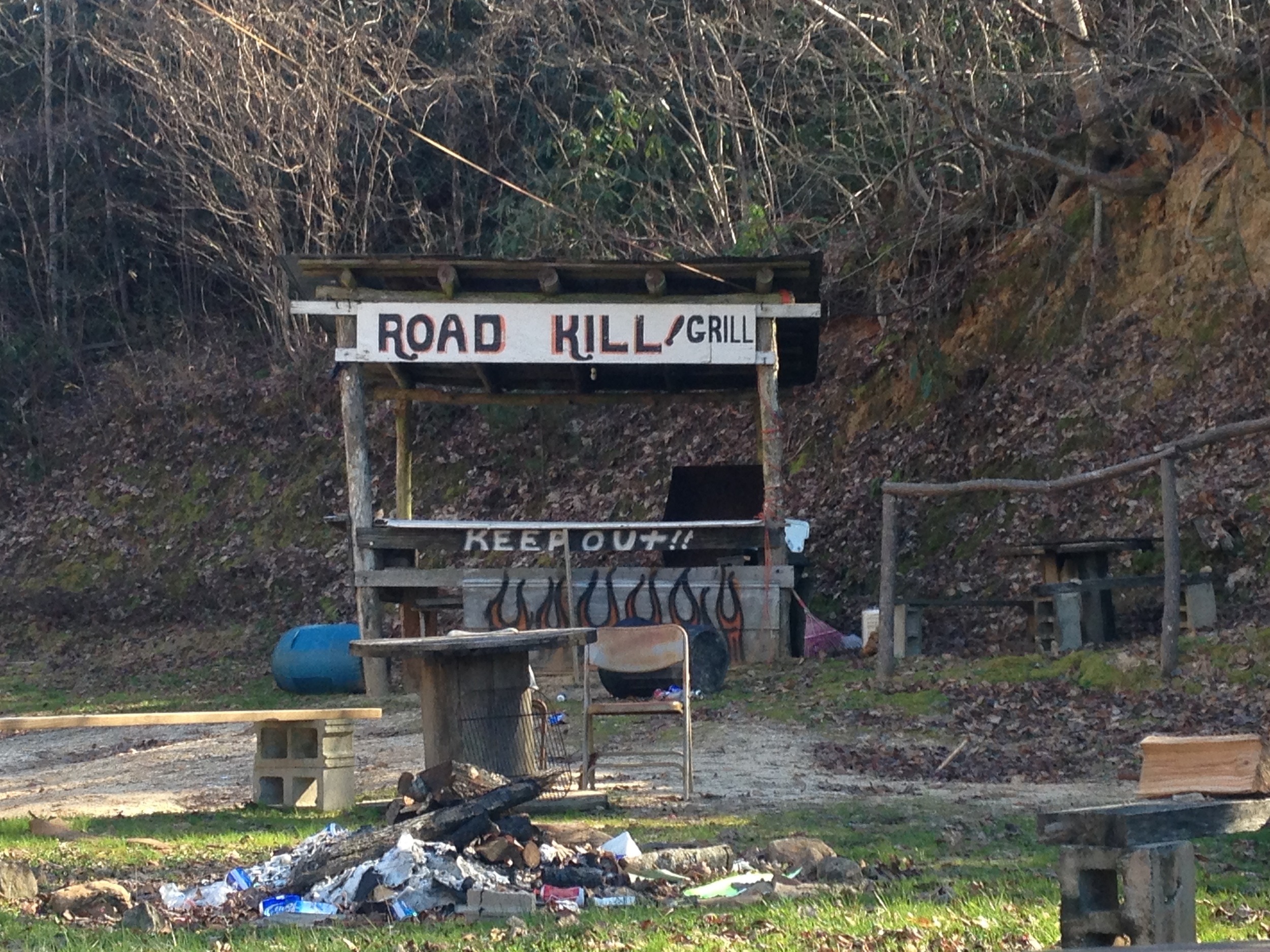
Fire it up.
It was fairly early, about 11:00 am. Bob's didn't seem open. I kept driving but vowed to return.
Another two hours of back roads curling through the South Carolina upstate brought me around to Table Rock State Park, where I've hiked and camped. I listened to old country radio. I watched vultures pick apart road kill (that had luckily escaped Bob's.) I let the sun warm me through the windshield.

I reached Paris Mountain State Park near 2:30 pm. It had been a rag-tag day, so I opted for a short jaunt rather than a full hike. It was Martin Luther King Jr. day, so a lot of families were out hiking since the kids were off from school. The park was bustling.
I ended up doing just under two hours on the Sulfur Springs Trail, one of the more famous in the park. I plan to return and do the full loop one of these warm days.
There are multiple access points to the trail. I started off from one of the parking lots where I saw many people hustling on and off the trail. Nearby, there were group picnic shelters and former scout camp gathering spots.

The trail was woodsy and straightforward. I quickly reached the namesake, Sulphur Springs, and the dam. The smell was not terribly strong, but still noticeable.
School kids on some kind of group outing were scrambling all over the place at the dam, so I pressed on.
A little ways beyond the dam wall, there was a nice "beach" where you could admire the view. I kept going, figuring I could rest on the way back.
I hiked probably 45 minutes deeper into the woods. The trail narrowed in as I went. There were several stream crossings and small waterfalls to admire.
The trail picked up the incline and I was definitely feeling the workout. I rested and decided to head back. It was growing dark at about 4:00, since I was in a valley and under a thick tree cover.

Feet up and happy.
I did stop and enjoy the view near the dam on the way back. The water, remarkably clear, was like a rainbow ribbon of green and blue.
By now, everyone had dissipated and I was alone. I dragged my fingertips across the chilled water, then perched on a rock to pass some time.
After about ten minutes of perfect solitude, I began the trek back to the car.
I still had several hours before I had to fetch my dad from the airport. I did a quick change in the park bathrooms and drove into Greenville for some food. I ended up hanging at an open mic night at Smiley's Acoustic Cafe for a while, listening, munching, sipping, and chatting with the bartender. A good end to a rambling mountain day.
